
Support
Secure Payment Methods
Book your Pakistan tour with confidence using our trusted international and regional payment options.




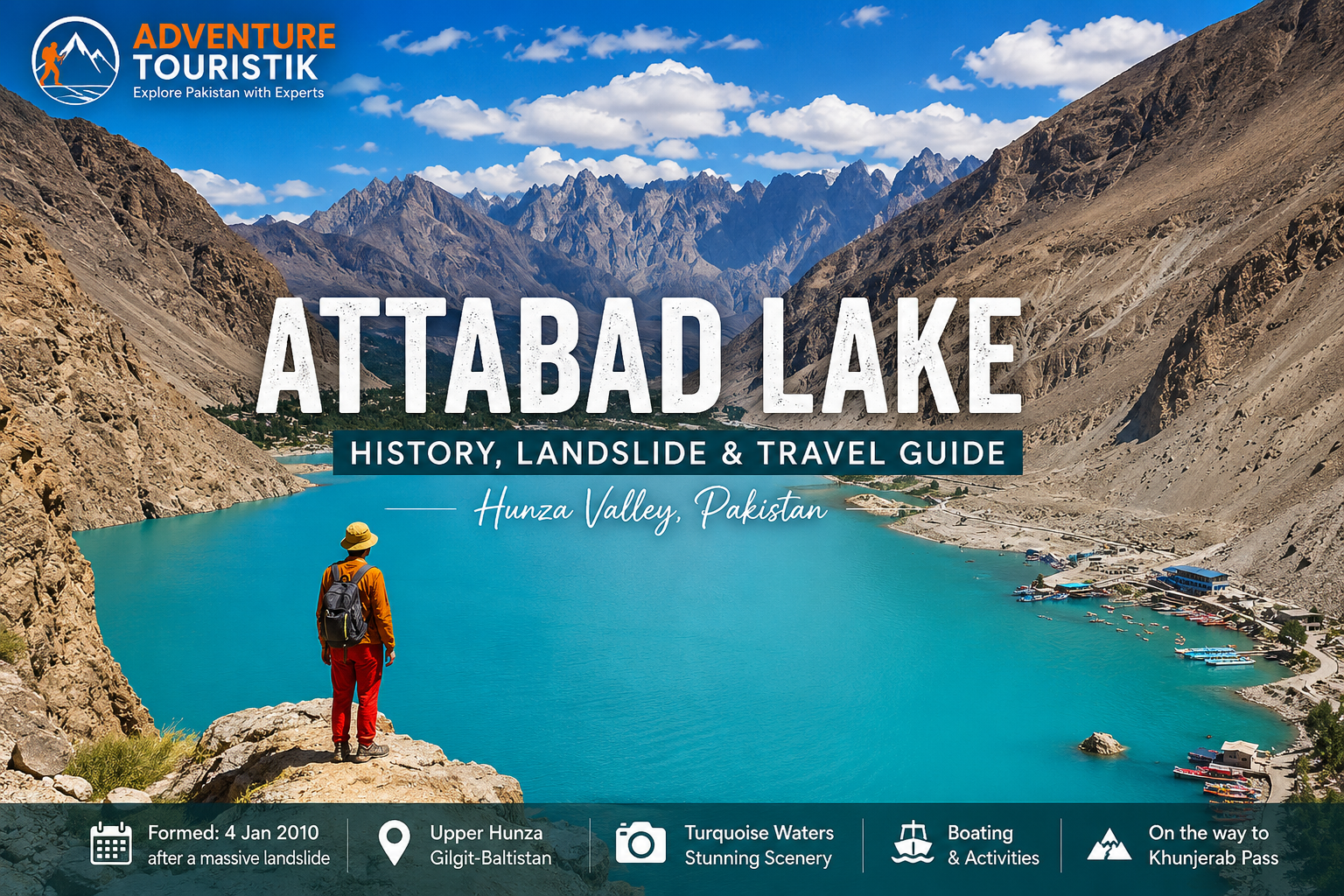
Attabad Lake is one of the most remarkable destinations in Hunza Valley, Gilgit-Baltistan, Pakistan. Famous for its striking turquoise-blue water and dramatic Karakoram Mountain scenery, the lake has become one of the most visited attractions along the Karakoram Highway. But behind its beauty is a relatively recent and powerful story. The history of Attabad Lake begins with a massive landslide on 4 January 2010, when a huge mass of rock and earth fell into the Hunza River near Attabad village and blocked the river's natural flow.
The resulting lake transformed the landscape of Upper Hunza. The disaster caused loss of life, displaced communities, submerged land and disrupted the Karakoram Highway. Over time, however, Attabad Lake developed into an important tourism destination, attracting travelers interested in the mountains, local culture, photography, boating and the extraordinary scenery of Hunza.
Today, a visit to Attabad Lake is more than a scenic stop. It offers an opportunity to understand how a major natural disaster changed the geography, transport routes and tourism economy of the Hunza region.
The most important chapter in Attabad Lake history dates to 4 January 2010. A massive landslide occurred near Attabad village in Gojal, Upper Hunza. The landslide sent enormous quantities of rock and debris into the Hunza River, creating a natural dam that blocked the river.
According to the Government of Gilgit-Baltistan Tourism Department, the landslide occurred approximately 14 kilometres upstream from Karimabad and killed 20 people. The blockage stopped the normal flow of the Hunza River and caused water to accumulate behind the landslide debris, gradually forming what is now known as Attabad Lake.
The event was not simply the creation of a beautiful lake. It was a major humanitarian and environmental disaster for communities living along the Hunza River and in the lower part of Gojal. As the water level rose, agricultural land, homes, roads and other infrastructure were affected.
The Attabad landslide changed the Hunza landscape almost overnight. The natural dam created by the landslide prevented the Hunza River from flowing normally downstream, causing the newly formed lake to expand upstream.
Contemporary reports recorded the loss of life in Attabad and the progressive flooding of settlements including Shishkat, Ayeenabad and parts of Gulmit as the lake expanded. The rising water also damaged important sections of the Karakoram Highway (KKH), creating a major transportation problem for communities in Upper Hunza and for traffic traveling toward the Pakistan-China border.
The disaster affected thousands of people in the wider Gojal area. Homes, agricultural land, businesses and transport infrastructure were disrupted, while the expanding lake physically changed the valley.
Attabad Lake is sometimes described as an artificial or man-made lake, but that wording can be misleading. The lake was not constructed through an engineered dam project. It is better described as a landslide-dammed lake or a natural lake formed when landslide debris blocked the Hunza River.
The dam itself was created by the natural movement of the mountainside. Water then accumulated behind the debris, producing the large body of water visible today.
This distinction is important when discussing the history of Attabad Lake because its origin is directly connected to geological processes rather than conventional dam construction.
The Hunza River is central to the story of Attabad Lake. Before the 2010 disaster, the river flowed continuously through the valley. When the landslide blocked the river, water began collecting behind the debris.
The resulting lake eventually became one of the defining geographical features of Upper Hunza. Today, the Hunza River continues to flow through the wider valley system, while Attabad Lake remains a dramatic reminder of the landscape-changing power of landslides in the Karakoram.
The 2010 disaster had a major impact on the Karakoram Highway. Sections of the original highway were inundated as the lake expanded, disrupting the road connection through Upper Hunza.
For local communities, the consequences were much greater than a temporary road closure. The Karakoram Highway is a vital transport corridor connecting settlements across the region and continuing toward the Pakistan-China border. The loss of sections of the road affected travel, trade and everyday transportation.
Over time, alternative road infrastructure and tunnels were developed to restore the highway connection around the lake. Today, travelers can drive along the Karakoram Highway beside Attabad Lake and continue toward Gulmit, Passu, Sost and Khunjerab.
The formation of Attabad Lake affected several communities in the surrounding area. As the water level increased, parts of settlements and agricultural areas were submerged or damaged.
Contemporary reporting documented the flooding of areas including Ayeenabad, Shishkat and Gulmit, while other nearby communities also experienced serious disruption. The disaster resulted in displacement and loss of homes, agricultural land and commercial property.
This human history should remain part of any responsible travel story about Attabad Lake. The turquoise water that attracts visitors today exists because of an event that caused enormous hardship for people living in the valley.
The dimensions of Attabad Lake have been reported differently at different stages of its formation and in different sources. Contemporary reports described the developing lake as extending for roughly 20 to 25 kilometres as the water level rose.
Rather than focusing on one fixed historical measurement, it is more useful for travelers to understand that the lake stretches for a considerable distance through the narrow Hunza landscape and is surrounded by steep Karakoram mountains.
One of the first things visitors notice is the intense blue and turquoise color of Attabad Lake. The appearance of the water changes with weather, sunlight, season and viewing angle, creating shades ranging from deep blue to bright turquoise.
The contrast between the colored water and the dry, rugged mountains surrounding the lake is one reason Attabad has become one of the most photographed places in Hunza Valley.
For photographers, the lake is especially impressive in clear weather when the surrounding peaks are reflected on the surface.
More than a decade after the 2010 disaster, Attabad Lake has become an important tourism destination in Gilgit-Baltistan. The Government of Gilgit-Baltistan identifies it as a major tourist attraction and highlights activities including boating, jet skiing and fishing.
The lake has also become an important stop for travelers driving the Karakoram Highway toward Upper Hunza and Khunjerab Pass. Its combination of dramatic scenery, accessible road connections and recreational opportunities makes it suitable for both short visits and longer Hunza itineraries.
Attabad Lake is more than a viewpoint. Travelers can spend several hours exploring the lake and surrounding landscape.
Boating is one of the most popular activities at Attabad Lake. A boat ride provides a different perspective of the surrounding mountains and gives visitors an opportunity to experience the unusual color of the water from the lake itself.
Attabad Lake is an excellent destination for landscape photography. The combination of turquoise water, steep mountain slopes, rocky terrain and changing light creates strong compositions throughout the day.
The journey to Attabad Lake is part of the experience. The Karakoram Highway follows the Hunza landscape and connects the lake with other major attractions in Upper Hunza.
Attabad Lake can easily be included in a wider Upper Hunza itinerary. Travelers can continue toward Gulmit, Passu, Hussaini, Sost and eventually Khunjerab Pass.
The surrounding region offers many additional places to explore, including Passu and other villages and viewpoints along the Karakoram Highway.
The best time to visit Attabad Lake depends on what you want to experience. Spring brings pleasant temperatures and emerging greenery, while summer is popular for road trips and outdoor activities. Autumn adds golden and reddish colors to the Hunza landscape, making it particularly attractive for photography.
Summer and early autumn are generally convenient for travelers planning a broader Hunza and Upper Hunza road trip. However, mountain weather can change quickly, so road conditions and local travel advice should always be considered before departure.
Attabad Lake is located in Gojal, Upper Hunza, in Gilgit-Baltistan. The lake is accessible by road through the Karakoram Highway.
For travelers arriving from Islamabad, a common route is Islamabad → Besham or Chilas → Gilgit → Hunza → Attabad Lake. Travelers already staying in Karimabad can continue north along the Karakoram Highway toward Attabad and Upper Hunza.
The lake is also commonly included in longer journeys toward Passu, Sost and Khunjerab Pass.
Attabad Lake is situated in the Gojal region of Hunza, Gilgit-Baltistan, Pakistan. A commonly mapped coordinate for the lake is approximately 36.346° N, 74.849° E.
Because the lake extends through a long mountain valley, coordinates can vary depending on which section, viewpoint or attraction is being mapped. For a tourism location page, the coordinates should therefore be treated as a central map reference rather than the exact position of every part of the lake.
The history of Attabad Lake is ultimately a story of both disaster and transformation. The 2010 landslide caused deaths, displacement and serious damage to communities and infrastructure. Yet the landscape that emerged from that tragedy later became one of the most recognizable tourism destinations in northern Pakistan.
Today, travelers arrive to photograph the blue water, ride boats and continue their journey through Hunza. But understanding what happened in 2010 gives the destination greater meaning.
Attabad Lake is not simply a beautiful lake. It is a visible reminder of the powerful geological forces that shape the Karakoram and of the resilience of the communities that continue to live and work in this extraordinary mountain environment.
Attabad Lake works particularly well as part of a multi-day Hunza Valley tour. Travelers can combine the lake with Karimabad, Baltit Fort, Altit Fort, Eagle's Nest, Passu Cones, Hussaini Suspension Bridge and Khunjerab Pass.
Adventure Touristik's 12 Days Hunza & Skardu Valley Tour includes Attabad Lake as part of its Hunza itinerary, together with Passu Cones, the Hussaini Suspension Bridge and other major destinations across the region.
For travelers who want more time in Hunza, a private itinerary can be arranged around photography, culture, history, nature, family travel or adventure activities.
Attabad Lake deserves more than a quick roadside photograph. Its history, mountain scenery and location along the Karakoram Highway make it an important stop for anyone exploring northern Pakistan.
If you are planning a Hunza Valley tour, Attabad Lake tour or a longer journey toward Khunjerab Pass and the Pakistan-China border, Adventure Touristik can help arrange a customized itinerary based on your travel dates, group size and interests.
Explore the history of Attabad Lake, travel through the spectacular Hunza Valley and experience the Karakoram landscape with a thoughtfully planned Pakistan tour.
Attabad Lake was formed in January 2010 after a massive landslide blocked the Hunza River. The landslide occurred on 4 January 2010.
Attabad Lake was caused by a massive landslide near Attabad village. The landslide blocked the Hunza River and created a natural dam, behind which water accumulated to form the lake.
The Government of Gilgit-Baltistan Tourism Department records 20 deaths from the 4 January 2010 landslide. Contemporary reports from the time recorded slightly different figures, which is why older sources may mention 19 or 21 deaths.
Attabad Lake is famous for its vivid blue and turquoise water, dramatic Karakoram scenery, boating opportunities and its unusual origin as a lake created by a major landslide in 2010.
Attabad Lake is best described as a natural, landslide-dammed lake. It was not constructed with an engineered dam. The landslide itself created the natural barrier that blocked the Hunza River.
Attabad Lake is located in the Gojal region of Hunza, Gilgit-Baltistan, along the Karakoram Highway in northern Pakistan.
Yes. Attabad Lake is a major tourist attraction and can be visited by road. Visitors commonly stop for sightseeing, photography and boating, depending on local operating conditions.
Popular activities include boating, photography, sightseeing and enjoying the mountain scenery. Attabad can also be combined with a wider Upper Hunza journey toward Passu, Sost and Khunjerab Pass.
Yes. Attabad Lake is commonly included in Hunza Valley itineraries. Adventure Touristik's 12 Days Hunza & Skardu Valley Tour includes Attabad Lake, Passu Cones and the Hussaini Suspension Bridge.
Spring, summer and autumn are popular periods for visiting Attabad Lake. Summer is particularly suitable for road trips and outdoor activities, while autumn offers attractive colors for landscape photography.
FEATURED ARTICLE
Explore the remarkable history of Attabad Lake and learn how the 4 January 2010 landslide blocked the Hunza River and transformed the landscape of Upper Hunza. Discover the communities affected by the disaster, the impact on the Karakoram Highway and how Attabad Lake later became one of northern Pakistan's most famous tourism destinations.
FEATURED ARTICLE
Discover Hunza Valley through its spectacular mountain landscapes, historic settlements, ancient forts and turquoise lakes. A Hunza itinerary can combine Attabad Lake with Karimabad, Baltit Fort, Altit Fort, Eagle's Nest, Passu and other attractions across the valley.
FEATURED ARTICLE
Explore Hunza and Skardu on a multi-day journey combining mountain scenery, cultural heritage and iconic lakes. The itinerary includes Attabad Lake, Passu Cones, Hussaini Suspension Bridge, historic forts and major attractions across Hunza and Skardu.
FEATURED ARTICLE
Continue beyond Attabad Lake along the Karakoram Highway toward Gulmit, Passu, Sost and Khunjerab Pass. This route combines the turquoise waters of Attabad with the dramatic Passu landscape, Upper Hunza communities and the high-altitude Pakistan-China frontier. Adventure Touristik's existing Khunjerab guide also positions Attabad Lake as a key stop on the route.
Thoughtful thoughts to your inbox
Book your Pakistan tour with confidence using our trusted international and regional payment options.
Follow us @AdvTouristik
Copyright © 2026 Adventure Touristik Pvt Ltd®. All Rights Reserved.

